National Electric Vehicle Infrastructure (NEVI) Program
The federal Infrastructure Investment and Jobs Act was signed into law on November 15, 2021 and established the National Electric Vehicle Infrastructure (NEVI) Program. NEVI will provide funding to states to deploy electric vehicle (EV) fast chargers along designated EV corridors to establish an interconnected EV charging network across the State and nation.
In July of 2023, the New York State Department of Transportation (NYSDOT) submitted New York’s NEVI Plan [PDF] update to the Joint Office of Energy and Transportation and the Federal Highway Administration (FHWA).
NEVI and New York
The NYSDOT will receive approximately $175 million through NEVI over five years. The NEVI program requires funds to be invested within one travel mile of designated EV corridors, with charging stations no more than 50 miles apart. Designated corridors include many of the State’s most-traveled interstate and state highways.
To receive the NEVI funds, NYSDOT submitted a State EV Infrastructure Deployment Plan (Plan) to the FHWA. The Plan contained information on the State’s existing charging infrastructure, goals for the investments, how the State plans to use the funding, and how the State will monitor and evaluate the program. Public input was an important part of Plan development. NYSDOT must submit updated plans to the Joint Office of Energy and Transportation and FHWA each year in order to receive its annual allotment. FHWA reviewed and approved these plans in September 2023.
Federal Grant Opportunity
The FHWA Charging and Fueling Infrastructure Discretionary Grant Program (CFI Program) is a new competitive grant program created by the Bipartisan Infrastructure Law to strategically deploy publicly accessible EV charging and alternative fueling infrastructure in the places people live and work, urban and rural areas alike, in addition to along designated Alternative Fuel Corridors (AFCs). This program provides two funding categories of grants: (1) Community Charging and Fueling Grants (Community Program); and (2) AFC Grants (Corridor Program). The Bipartisan Infrastructure Law provides $2.5 billion over five years for this program. This first round of funding makes $700 million from Fiscal Years 2022 and 2023 funding available to strategically deploy EV charging infrastructure and other fueling infrastructure projects in publicly accessible locations, including downtown areas and local neighborhoods, particularly in underserved and disadvantaged communities.
More information on the program, eligibility requirements and application deadlines ![]() .
.
Share Your Input
New York State will provide the public and interested parties with regular, transparent, and effective access to information and decision-making.
New York State held a virtual public information meeting on the NEVI Plan on July 20, 2022. Slides from the meeting are available here [PDF].
You can sign up to receive future program updates and notices of outreach and engagement opportunities.


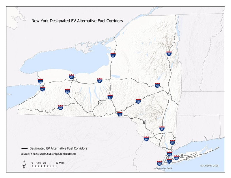
Download the Full New York State Corridor Map Now [GIF]
Description: This map shows the interstates and highways statewide that are designated Electric Vehicle corridors:
- New York City Metro Area
- Interstate 84 – Pennsylvania/New Jersey border to Connecticut border
- Interstate 684 – Interstate 84 to Interstate 87
- Interstate 95 – New Jersey border to Connecticut border
- Interstate 495 – Manhattan to Riverhead
- Interstate 278 – New Jersey border to Interstate 95
- Interstate 678 – Interstate 95 to JFK Airport
- Interstate 287 – New Jersey border to Interstate 95
- NY-25 – Interstate 495 to Riverhead
- NY-27 – Interstate 278 to Montauk
- Eastern New York
- Interstate 87 – Canada border to New York City
- Interstate 90 – Syracuse to Albany
- Central and Western New York
- Interstate 90 – Interstate 90 to Canada border
- Interstate 490 – Interstate 90 to Victor
- Interstate 90 – Pennsylvania border to Syracuse
- Interstate 81 – Canada border to Pennsylvania border
- Interstate 390 – Rochester to Interstate 86
- Interstate 86 – Pennsylvania border to Elmira
- Interstate 86/NY-17 – Elmira to Interstate 87
- Interstate 88 – Interstate 81 to Interstate 90
- NY-13 – NY-17 to Interstate 81
More details on the Statewide map More details on the Statewide map


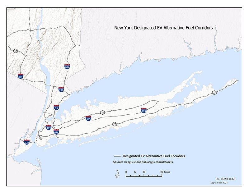
Download the Full NYC Corridor Map Now [GIF]
Description: This map shows the interstates and highways in the New York City area that are designated Electric Vehicle corridors:
- Interstate 84 – Pennsylvania/New Jersey border to Connecticut border
- Interstate 684 – Interstate 84 to Interstate 87
- Interstate 95 – New Jersey border to Connecticut border
- Interstate 495 – Manhattan to Riverhead
- Interstate 278 – New Jersey border to Interstate 95
- Interstate 678 – Interstate 95 to JFK Airport
- Interstate 287 – New Jersey border to Interstate 95
- NY-25 – Interstate 495 to Riverhead
- NY-27 – Interstate 278 to Montauk
More details on the NYC corridor map More details on the NYC corridor map
Important Resources
- Joint Office of Energy and Transportation

- NEVI Program Guidance
 [PDF]
[PDF] - Alternative Fuels Data Center

- Final Rulemaking: National Electric Vehicle Infrastructure Standards and Requirements

- NEVI Program Frequently Asked Questions
 [PDF]
[PDF] - Charging and Fueling Infrastructure (CFI) Discretionary Grant Program


